


East Timor is divided into 13 administrative
districts:
Aileu
Ainaro
Baucau
Bobonaro
Cova-Lima
Dili
Ermera
Lautém
Liquiçá
Manatuto
Manufahi
Oecussi-Ambeno
Viqueque
Ainaro
Baucau
Bobonaro
Cova-Lima
Dili
Ermera
Lautém
Liquiçá
Manatuto
Manufahi
Oecussi-Ambeno
Viqueque
Aileu
Aileu is an administrative district of East Timor.
Ainaro
Ainaro is one of 13 administrative districts of East Timor.
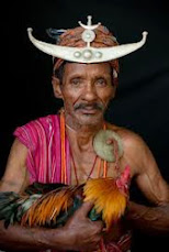
Ainaro district is in the southwest of the country. It boasts many streams, fertile land and rugged terrain, including East Timor’s highest peak, Mount Ramelau. Historically, Ainaro played an important role during the brutal Indonesian occupation of East Timor, providing shelter for the mountain-based guerrilla resistance army. Former guerrilla leader and current President Xanana Gusmão spent many years directing the resistance from Ainaro.
Ainaro sub-district & town
Ainaro sub-district has a population of approximately 12,000 people.
Ainaro sub-district & town
Ainaro sub-district has a population of approximately 12,000 people.
The small mountain town of Ainaro, the district capital, lies along with the villages of Soro, Maununo, Cassa, Suro Craic, Manutassi, and Mau-Ulo in the sub-district.
The town's main resources are its delicious organic coffee and aromatic sandalwood trees. It is a diverse community, where Catholics, Protestants, and Muslims are neighbors.
Destruction of Ainaro
Ainaro was also home to a large contingent of Indonesian military (TNI) backed militias in the months leading up to the August 30th, 1999 referendum on independence. As a result it suffered near-total devastation during the TNI orchestrated scorched earth operation with more than 95 percent of its buildings destroyed.
Baucau
Baucau is the second largest city in East Timor, after the capital, Dili. It is also one of the districts of East Timor.
Baucau is the second largest city in East Timor, after the capital, Dili. It is also one of the districts of East Timor.
Bobonaro
The Bobonaro district is the second most western district on the east half of the island. Bobonaro contains East Timor's fourth largest city, Maliana, which is also the district's capital. As of 2004 it has a population of 13,200, and sits at 9.00°S and 125.22°E. The next two largest cities in the district are Aubá, with 6,700 people; and Lolotoi with a population of 3,800. It had been a popular destination in Timor, due to its mountains and hot springs, but it has suffered much violence in the war for independence.
The Bobonaro district is the second most western district on the east half of the island. Bobonaro contains East Timor's fourth largest city, Maliana, which is also the district's capital. As of 2004 it has a population of 13,200, and sits at 9.00°S and 125.22°E. The next two largest cities in the district are Aubá, with 6,700 people; and Lolotoi with a population of 3,800. It had been a popular destination in Timor, due to its mountains and hot springs, but it has suffered much violence in the war for independence.
Cova-Lima
Cova-Lima is one of the districts of East Timor.
Dili, also spelled Díli, Dilli or Dilly, is the capital of East Timor. It lies on the northern coast of Timor island, the easternmost of the Lesser Sunda Islands. Dili is the chief port and commercial centre for East Timor, and has approximately 150 000 people. There is also an airport in Comoro, renamed after independence leader Nicolau Lobato, which is used for commercial and military flights. Dili is located at 8°34' South, 125°34' East (-8.5667, 125.5667). It is also the name of the surrounding administrative district.
Ermera
Ermera is one of the districts of East Timor.
Lautém
Lautém is one of the districts of East Timor.
Liquiçá
Liquiçá is one of the districts of East Timor.
Liquica is situated on the northern part of Dili and its capital is situated around 35 km from Dili.
During the beginning of the Portuguese occupation, a part of the Liquisa territory was taken by the Netherlands (Holland), it was Maubara sub-district. The Maubara fortification that lies near the the beach was built by Holland. Later on, Portuguese negociated with Holland and exchanged it with Flores Island, that was ocupied by Portuguese by that time. During the Indonesian ocupation, the Indonesian government has done many things, but after the referendum 1999 and during the militia`s campaign almost everything has been destroyed. Liquisa is one of the districts that suffered a lot the militia compaign. There were many people killed during the Liquisa Church massacre.
During the beginning of the Portuguese occupation, a part of the Liquisa territory was taken by the Netherlands (Holland), it was Maubara sub-district. The Maubara fortification that lies near the the beach was built by Holland. Later on, Portuguese negociated with Holland and exchanged it with Flores Island, that was ocupied by Portuguese by that time. During the Indonesian ocupation, the Indonesian government has done many things, but after the referendum 1999 and during the militia`s campaign almost everything has been destroyed. Liquisa is one of the districts that suffered a lot the militia compaign. There were many people killed during the Liquisa Church massacre.
Manatuto
Manatuto is one of the districts of East Timor.
Manatuto is one of the districts of East Timor.
Manufahi
Manufahi is one of the districts of East Timor
Manufahi is one of the districts of East Timor
Oecussi-Ambeno
Oecussi-Ambeno (also variously Ocussi, Oekussi, Oekusi, Okusi, Oé-Cusse) is a district of East Timor. It is a coastal exclave on the western part of the island of Timor, separated from the rest of East Timor by West Timor, which is part of Indonesia. The capital of the province is Pante Macassar, also called Ocussi Town.
Oecussi-Ambeno (also variously Ocussi, Oekussi, Oekusi, Okusi, Oé-Cusse) is a district of East Timor. It is a coastal exclave on the western part of the island of Timor, separated from the rest of East Timor by West Timor, which is part of Indonesia. The capital of the province is Pante Macassar, also called Ocussi Town.
It was in Pante Macassar that an Indonesian fifth column raised the Indonesian flag and took control of the exclave on 29th November, 1975, a week before the Indonesian invasion of East Timor proper. However, even under Indonesian rule, Oecussi-Ambeno was administered as part of the province of East Timor, just as it was as part of Portuguese Timor. Consequently, it became part of the independent state of East Timor in 20 May 2002.
Viqueque
Viqueque is one of the districts of East Timor.